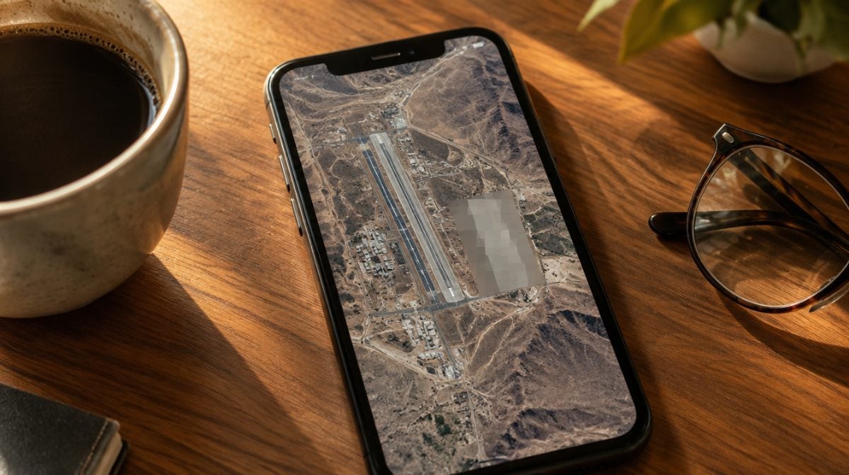
Reported on October 30, 2026, the list of Apple Maps blurred areas suddenly got longer, and it is a very particular list. Pan over “Whiteman Air Force Base” in the satellite view and zoom in, and the detail you would expect gives way to a deliberate smear. The change, first spotted by Space Explored, came with no announcement from Apple and appears to cover a handful of NASA, Space Force and Air Force sites.
For most people this changes nothing about getting to the grocery store. It does change what you can see from your couch, and it raises a fair question about how Apple decides what stays visible.
Which sites are now Apple Maps blurred areas
Nine locations were reported as hidden. The list leans toward launch sites, Air Force bases and research facilities.
| Location | Status in Apple Maps |
|---|---|
| Wallops Flight Facility (Virginia) | Airfield blurred, launch pads still visible |
| Stennis Space Center (Mississippi) | Blurred |
| Cape Canaveral Space Force Station (Florida) | Blurred |
| Patrick Space Force Base (Florida) | Blurred |
| Vandenberg Space Force Base (California) | Blurred |
| Whiteman Air Force Base | Blurred |
| Ellsworth Air Force Base | Blurred |
| Groom Lake | Blurred |
| Los Alamos National Laboratory | Blurred |
| Kennedy Space Center, Launch Complex 39A and 39B | Still visible |
| Pearl Harbor, Norfolk, Naval Station Great Lakes | Still visible |
| Dyess and Barksdale Air Force Bases | Still visible |
Two Air National Guard bases in Wisconsin also stayed sharp. So this is clearly not a blanket rule that hides every military installation in the country.
How the blurring works in plain English
Think of the new Apple Maps blurred areas as a frosted window laid over specific patches of the map. The site is still on the map, but the close-up view of runways, parked aircraft and launch hardware is what goes soft.
The examples shared so far involve the satellite layer, such as the view over Whiteman. Nobody has published which zoom level triggers the blur, and it is not confirmed whether 3D views behave the same way. Treat any claim beyond the satellite view as unverified for now.
One detail stands out: these Apple Maps blurred areas had no match in Google Maps when the change was found, so the same base can look crisp in one app and fuzzy in the other.
Why does Apple Maps blur military bases?
Apple has not explained it. The obvious reading is security: a sharp overhead view of an air base or a launch site is the sort of thing defense officials would rather not hand to anyone with a phone. That is a reasonable guess, not a confirmed reason.
The patchwork is the more interesting part. Kennedy’s famous pads remain on display while Cape Canaveral next door is hidden. At Wallops, the airfield vanished but the launch pads did not. That pattern points to site-by-site decisions, possibly made at the request of whoever runs each facility, rather than a single switch Apple flipped for every base.
Because there was no announcement, nobody outside Apple knows how many more Apple Maps blurred areas are coming, or whether the effort will stretch to other government property.
What it means for you
Everyday drivers. If you never route to a military gate, the Apple Maps blurred areas will not touch your day.
People who work on or visit these bases. This is the open question. It is not yet clear whether turn-by-turn directions, including through CarPlay, still work normally once you are inside a blurred zone. If you rely on Apple Maps to find a building on base, check your route before you leave and keep a backup.
Space and aviation fans. Kennedy’s pads are still there to explore before a launch trip. For the rest of the list, the overhead view is gone in Apple’s app.
If you spot a blur that seems to be in the wrong place, Apple has an official guide to reporting an issue with Maps on iPhone. Just do not expect a response that restores a hidden air base. If you are new to the app’s newer tricks, our look at the Apple Maps Library and Notes features covers the basics of saving places.
Common misconceptions about the blur
- “Apple is hiding a secret new facility.” Most of these sites are widely known by name. The blur hides detail, not existence.
- “Every base is gone now.” Pearl Harbor, Norfolk, Dyess and Barksdale were all still visible when the change surfaced.
- “Every map app does this.” At the time, Google Maps had not applied the same blur to these locations.
- “Your street could be next.” Nothing reported links the Apple Maps blurred areas to homes or neighborhoods. The change targets a short list of government sites.
Apple has redrawn parts of its maps before, sometimes for spectacle, like the detailed Formula 1 circuit views. This time it went the other way and took detail out.
Frequently asked questions
Why does Apple Maps blur airports?
The blurring reported so far covers military airfields such as Whiteman and Ellsworth plus the airfield at Wallops. Apple has not said anything about public passenger airports.
Does Google Maps blur the same military bases?
Not when the change was found. Google Maps had not blurred any of the military sites on Apple’s list, so the two apps show different levels of detail.
Did Apple announce the new blurred areas?
No. Apple made no announcement and has not explained the change, so its reasons and any future additions are unconfirmed.
Should the blur change how you use Apple Maps?
For nearly everyone, no. Keep using it as you always have. If your job or a family visit takes you onto one of these bases, test your directions ahead of time until it is clear how navigation behaves inside the fuzzy zones. The Apple Maps blurred areas are small for now, and the rest of the map is exactly as sharp as it was last week.